Change of Plans: Bahamas to …(part 1)
I am coming to realize that cruising is not about sailing. It’s about getting from one place to the other with yourself and the boat intact.
Plans are like the weather. They change constantly. We signed on with a weather router to help us with our voyage planning and decision making. He suggested, due to unstable weather conditions, we might want to opt for shorter hops from island to island rather than looking for a longer weather window to go directly to St. Thomas. At his suggestion, we decided to take a short hop south to George Town on Great Exuma Island. Once there, he then advised us to wait (ugh) as multiple thunderstorms and more unsettled weather patterns were forecasted for the next few days.
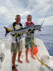 Our trip to George Town was highlighted by a 25 pound Wahoo that Sam and Jim reeled in. Otherwise, it was a motor trip, dodging storms. We spent 2 days in George Town. Unfortunately, Sam’s time off to be with us was running short. So he made his plane reservation to head back home on Friday.
Of course now, Friday afternoon, our weather router told us that we had a weather window for St. Thomas opening up Saturday afternoon or Sunday morning! Are you seeing the pattern of change??? We decided on a Sunday morning departure. Our weather router sent us a detailed route from George Town to St. Thomas, with the caveat “However, there is a heightened potential for some stronger storms to be moving through the region around sunset on Sun[day], and wind in any of these squalls may be in excess of 40k [46 mph]. As a result, you may want to consider briefly stopping near Conception Island or Rum Cay if you are able to monitor the radar in real time to stay aware of any storms that may impact your trip.”
The forecasted wind direction for Sunday night was from the west. This made Rum Cay and Conception Island poor choices for anchorages. We consulted the cruising guide and decided to head for Clarence Town on Long Island. This would give us protection from the westerlies. We planned to depart Georgetown early morning on Sunday and make 77 miles south to Clarence Town before anchoring for the night.
We weighed anchor at 6 am as planned. At 7 am we got an error message on our chart plotter that the radar was not communicating with the chart plotter. The only way to correct this was to reboot our finicky chart plotter. By “finicky” I mean, sometimes it just doesn’t want to come back on. Well, well, well. The chart plotter didn’t come back on. Plan B. We had an alternate chart to use for navigation. This we always have as a back up. What we didn’t have a back up for was radar, to monitor storms and other vessels at night. Kinda important. Also, no AIS (Automated Identification System). This is the system to see and identify other boats, their course and speed, and the CPA (closest point of approach) . Collision avoidance is also kinda important.
We arrived to Clarence Town and had our anchor down by 5:50 pm. We tried and tried, with no success, to restart the chart plotter. No radar or AIS meant no traveling in the dark for us. Change of plans, again. No 3+ day passage to St. Thomas. Our other option was to go to the Dominican Republic via Turks and Caicos. Then to Puerto Rico then to the Caribbean. This is commonly known in the cruising world as “the thorny path”. This would be several short motor trips against wind and waves across the top of the Dominican Republic (DR), then across the infamous Mona Passage between the DR and Puerto Rico. But first we had to get to the DR.
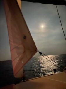
Motor sailing under a moonlit sky.
We then decided to head to the next set of islands in the Bahamas. The Acklin Islands. Being just 2 days out from a full moon, the night sky could be pretty bright. Visibility could be very good. If (big IF) the weather was good (calm) and the visibility was good (clear skies) we would continue through the night on to Turks and Caicos (TCI).
Our plan was working. Clear skies and gentle winds made for a nice motor sail past the Acklins, and TCI. Just past TCI our route would take us due south towards Luperon DR. Reaching Luperon would feel like a huge step towards getting to the Caribbean. We turned south just past Grand Turk Island. DR here we come!
Did I say our plan was working? Well, it was until about 4 am. The winds and waves began to build. By 6:30 am, our speed was cut in half. The boat was bashing into the waves. At this rate we would not be in Luperon until 1 am the next morning. Not willing to subject ourselves or the boat to these conditions, we elected to turn around and make the 6 hour trip downwind with following seas back to TCI.
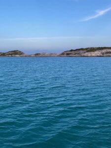
Consolation prize. Another pretty anchorage.
We were cleared in and safely anchored in Cockburn Harbour, South Caicos Island by 3pm.
Leave a Reply