Samana’, Dominican Republic (DR) to Grenada, West Indies (WI)
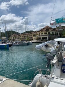
Marina Puerto Bahia Samana’ DR
We decided that our initial destination after leaving Marina Puerto Bahia on the northeast side of the Dominican Republic would be St. Croix in the USVI. After Tropical Storm Bret passed (there were no effects felt in Samana’) we would have a 289nm trip to St. Croix. We left on Sunday, June 25th at 7:00am. The trip would be a continuation of “The Thorny Path”. The area between the DR and Puerto Rico is known as the Mona Passage and there are frightening stories of how rough the conditions can be as wind, waves, swell, and current are all heading west while poor souls are trying to go east. As things turned out, the Mona Passage was the easy part of the trip. We timed our crossing well, took Van Sant’s advice to sail north past Hourglass Shoals before heading southeast toward the southwest corner of Puerto Rico. We were there the next morning around 10:30am with approximately ½ of the passage behind us.
To our slight surprise the southern coast of Puerto Rico was not friendly. We experienced a surprisingly stiff current of between 1.5 – 2.1 knots the entire way to St. Croix. The seas were consistently 6+ feet or more and we had a breeze of 12 -17 knots only 25 degrees off our bow. The ride was uncomfortable and slow! Even at higher RPMs than we usually motor, we were going very slow. We also noted our rudders seemed sluggish. Since we were motor sailing, we checked our fuel consumption a couple of times and were surprised at how much diesel we were burning. The final 139nm of our passage took more than 30 hours, a distance we would normally cover in 20 hours or slightly more. We anchored at Frederiksted around 2:00pm on Tuesday, the 27th. When we checked our fuel levels, we were shocked to find we had less than ¼ of a tank in each diesel tank. Our starboard tank was the lowest at 1/8 tank, which was odd as our generator feeds off the port tank, so our starboard tank “always” had more fuel than the port side. (We also carried 40 gallons in jerry cans on deck, which we had not used.) We had never gone under ¼ tank before. After anchoring we dove in the water to make sure the anchor was well set. Linda immediately discovered that we had a line wrapped in our starboard prop and wrapped tightly in the rudder on that side.

Line discovered tangled in starboard rudder and prop.
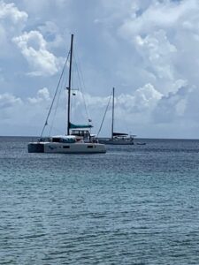
At anchor in Frederiksted USVI
There was no place to refuel in Frederiksted, so a couple of days later we moved 17.5nm to Christiansted on the north coast. We were there for only two days but found a couple of good restaurants. Christiansted is “Dutch Caribbean”, very much like St. Thomas 41nm to the north. We contemplated a stop at Buck Island, but we had a decent weather window to make more easting, and on Saturday, July 1, we headed out for Grenada.
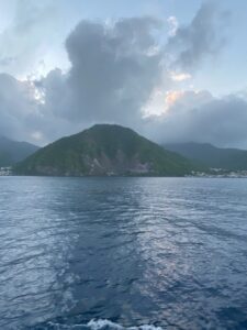
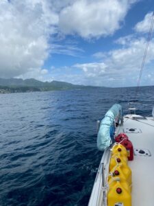
Leaving Dominica.
We left Dominica at 5:30am on Thursday, July 6th. Our passage to Grenada would be a little more than 200nm and take about 36 hours. We were well east in Dominica, in fact, Grenada is slightly west of Dominica. That’s important, because finally – The Thorny Path was in our wake, we were in position to ride the Tradewinds not fight them! Even though the winds were now favorable, the passes between islands create acceleration zones for winds, waves, swell, and current. It means it can still get nasty when one leaves the lee of an island. If you look at a map of the eastern Caribbean, it’s easy to envision. The winds, waves, swell, and current rushing from the Atlantic into the Caribbean Sea funnel between, around, and over (the wind) the islands. Additionally, the end of each island is a cape, and capes always disrupt the existing sea state. The seas between islands can get very rough because of the acceleration that results. We thought we’d have good conditions behind the islands (20 – 30 nm out) but tough conditions in all the acceleration zones. We were wrong! We had very good conditions in the lees and better-than-expected conditions in the acceleration zones. Compared to The Thorny Path, it was a sleigh ride!
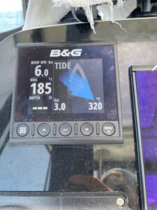
3.2 knot current against us.
We did encounter extremely strong currents in the passes, up to 3.2 knots. The currents were against us, but the sea state remained settled, and Ocean Song was comfortable. The morning of day #2 we thought about anchoring at Carriacou, which is a northern island of Grenada, but we were a few hours ahead of schedule and decided to carry on to St. George’s, Grenada’s capital, at the southwestern tip of Grenada. It would be another 6 -7 hours, but the conditions were very good, and we wanted to take advantage of them. Around 1:00pm on Friday afternoon we were sailing in waters we had sailed in 9 years ago on a charter vacation with friends. It all seemed familiar. By 5:00pm we were moored just outside the harbor at St. George’s. In fact, we picked up the very last available mooring ball in a mooring field with approximately 50 moorings.
Cruising down the west coast of Grenada.
 We feel a great sense of accomplishment having reached Grenada. We also feel “settled”. Now we look forward to finally living a cruising lifestyle. Exploring islands. Learning about other cultures. Meeting fellow cruisers, some of whom we have communicated with for years over social media and through sailing forums. This has been quite a journey so far. But it is only the beginning.
Leave a Reply